A detailed overview of road infrastructure in Papua New Guinea including the National Road Network and the National Road Network Strategy.

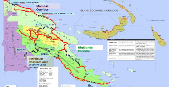
PNG’s planned road corridors Source: Department of Works
Overview
There are approximately 30,000km of roads and about 746 bridges in PNG. Of these 8,740km make up the National Roads network (NRN).
22,000km are provincial and district roads. The NRN is further classified into Priority Core Roads (2,309km), Priority Non-Core Roads (2,050km) and other National Roads (4,379km).
The National Road Network is the economic backbone of PNG and it carries about 89 per cent of all nationwide passenger and freight traffic. However, funding for the NRN has been inadequate for many years compounded by allocation of limited funds for unprioritized projects. Many of the bridges have deteriorated and pose a traffic danger. The terrain is mountainous and the weather is problematic, especially the heavy rainfall, landslides and earthquakes.
The National Government, consequently, has invested heavily in rehabilitating and upgrading the national roads.
In 2020, the PNG Government announced a 20-year road transport infrastructure program called Connect PNG 2020–2040, which identifies key economic corridors and the country’s funding and building priorities. The program will be delivered by the Department of Works and Implementation.
National Road Network Strategy
Coordinated by the Department of Works and Implementation, PNG’s National Road Network Strategy 2018–2037, will be undertaken in five-year steps, involving the expenditure of K21.1 billion to improve the condition of the national road network.
It will be delivered with reference to the Connect PNG program.
The first phase (2018-2022) will be focused on the 2309 km of core national roads, with K4.49 billion allocated.
Phase Two (2023-2027) will focus on the 2502 km of priority national roads; K4.81 billion will be allocated. Phase Three (2028-2037) will be directed at 4,639 km of non-priority national roads. It is expected that K11.82 billion will be expended.
The national road network is to be built around five economic corridors:
- Momase corridor spanning West Sepik, East Sepik, Madang and Morobe.
- The Highlands corridor, including Eastern Highlands, Chimbu, Jiwaka, Western Highlands and Enga.
- The Petroleum Resource Area-Southern Region (PRASR) corridor, which covers the provinces of Hela, Southern Highlands, Gulf, Central, Northern and Milne Bay.
- The Islands Region corridor, which includes the provinces of East New Britain, West New Britain, New Ireland, Bougainville and Manus Island.
- The Border corridor, which spans West Sepik and Western provinces.
The most important road in PNG is the Highlands Highway, which connects the Highlands to the port of Lae. The Asian Development Bank (ADB) commenced the Sustainable Highlands Highway project in 2017. It will cost US$1 billion (K3.32 billion) and will run until 2027. The ADB will work on the whole highway simultaneously, rather than in sections, and contractors who win the tenders to construct the roads will be required to maintain them for five years after they have been completed.
One proposed road and sea project is the landmark of a new Gulf Road that will connect Gulf Province with Port Moresby. The International Finance Corporation (IFC) is scoping the proposed route, which would require the co-operation of multilateral institutions, the National Government, the oil and gas majors that have operations in the province and private ferry operators. The road could reduce the time taken to transport produce from the Highlands to consumers in Port Moresby to two days rather than the current 10.
Announced in July 2019 and designed to target unmet demand for infrastructure in the Pacific, the Australian Infrastructure Financing Facility for the Pacific (AIFFP) is part of Australia’s Pacific Step-up program, aimed at deepening engagement with the region. As such, it is aligned to Australia’s foreign policy objectives and is managed by its Department of Foreign Affairs and Trade’s Office of the Pacific.
Tax credits for infrastructure development
A tax credit is available to taxpayers engaged in mining, petroleum or gas operations as well as taxpayers engaged in primary production and tourism. The credit operates by deeming relevant eligible expenditure to be tax paid by the particular taxpayer. The maximum amount of credit that can be claimed is limited to the lesser of the amount actually spent and:
- in the case of taxpayers engaged in tourism the amount of tax payable or 1.5 per cent of the assessable income for the year
- in the case of taxpayers engaged in primary production the amount of tax payable or 1.5 per cent of the assessable income for the year
- in the case of taxpayers engaged in mining, petroleum or gas operations the amount of tax payable or 0.75 per cent of the assessable income for the year
If a taxpayer’s expenditure in a particular year is less than these limits, the excess can be carried forward for a period of two years.
A prescribed infrastructure development for resource projects and primary producers includes schools, aid posts, hospitals, roads and other capital asset as well as maintenance of these assets (where these are owned by the State). Any projects must be approved, beforehand, by the Department responsible for national planning matters and all subsequent expenditure must be certified by both the Department and the Internal Revenue Commission as having been incurred.
Capital projects that are required to be built under a resource agreement are ineligible for the credit. For the tourism industry, the infrastructure tax credit scheme only extends to those who qualify as large scale tourism investors.
What else would you like to know?
This sector file is a living document created as a service to our subscribers. It is updated from time to time, as new information comes to hand.
Is there something else you’d like to know about this sector? Is there new information we haven’t included? Let us know in the Comment section below, or email editor@businessadvantageinternational.com and we’ll look into it.


Speak Your Mind